• Skip to primary navigation
  • Skip to main content
Complete Streets for Canada

Complete Streets for Canada

  • Map
  • Resources
  • News
  • About
Back to map

Waterloo

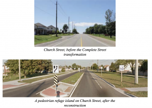
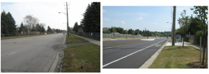
The City of Waterloo is a lower-tier municipality in the Regional Municipality of Waterloo approximately 100km west of Toronto. Having key staff and Council members champion Complete Streets made Waterloo a pioneer and the second municipality in Canada to adopt a Complete Streets policy.

Waterloo was included as a case study in TCAT’s Complete Streets Gap Analysis (2012) and in a backgrounder on Rural Complete Streets (2016).

Case Study | 2013

Church Street | 2013

In 2016, TCAT conducted a scan of Complete Street best practices in rural municipalities. The objective was to look at the unique challenges that rural areas face in adopting and implementing Complete Street policies and also to share some of the success stories that have come out of these communities. TCAT released a backgrounder on Rural Complete Streets featuring case studies in the Region of Waterloo (Elmira), the City of Thunder Bay and the District of Clearwater.

Description

The community of Elmira (population 9,931) is located 15 minutes away from Kitchener-Waterloo, within the rural Township of Woolwich, which is part of the Regional Municipality of Waterloo, Ontario. In 2013, its main, regional road, Church St, was set to be reconstructed due to the deteriorated quality of its asphalt, insufficient storm-water drainage, aging utilities, and increased turning traffic. The road was designated a Rural Village Main Street in the Region of Waterloo’s Context-Sensitive Regional Transportation Corridor Guidelines, meaning that active transportation and moving motor vehicles efficiently at an appropriate speed were automatically priorities.

The new design included a new sidewalk on the north side of the street where there had been none before, three landscaped pedestrian refuge islands, new street lighting, and 1.5 metre-wide on-road cycling and horse and buggy lanes. During public consultation, some residents expressed concerns that the width of the cycling and buggy lanes was too narrow to accommodate buggies, which are typically 1.54m wide, with some larger models in use. The project team decided not to expand the lanes, on the basis that a wider lane would encourage illegal parking, similar projects in other rural villages had been successful, and previous consultations with the Mennonite community had settled on this design. The number of pedestrian refuge islands was reduced, however, from seven to three, to allow adequate opportunities to safely pass buggies.

Davenport Road | 2011

Davenport Road in Waterloo, Ontario was one of nine Complete Streets projects profiled in TCAT’s Complete Street Transformations.

Description

Before the redesign, Davenport Road was in poor condition (it was built in the 1970s). The layout contributed to speeding and car accidents. At the same time, pedestrians and cyclists commonly used the road to reach Conestoga Mall and nearby neighborhoods. A traffic study completed in 2006 recommended a number of traffic calming solutions as well as bicycle facilities to address the problem. In April 2006, Waterloo Council gave their support to the recommendations. Two public information sessions were held for this study to provide the community and area stakeholders input into the final outcome (City of Waterloo, 2011). The Davenport Road redesign was made possible through the Build Canada Fund. The goal of the redesign was to: reduce automobile collisions, implement cycling infrastructure as directed by the cycling master plan, encourage active transportation by connecting two residential neighbourhoods and a regional shopping mall by installing multiple crossing opportunities, and provide transit improvements through bus pads and shelters.

Outputs

  • Painted bike lanes and bike box for safer cyclist turns
  • Four traffic lanes converted to two with a median sometimes giving way to a centre turn lane
  • Landscaped centre medians, pedestrian refuge islands, and a roundabout
  • Improved pedestrian crossings at intersections
  • New curb ramps to improve accessibility
  • Over 300 trees and other vegetation planted
  • New bus shelters and transit pads

Outcomes

  • Collision rate declined from 16 per year from 2004 to 2008, to 12 collisions per year from 2012 to 2014.
  • Automobile operating speed (85th percentile) has dropped from over 70km/h in 2005, to between 62 to 66 km/h in 2015. Average speeds have dropped as well, and are now closer to the 50km/h limit.

Transportation Plan | 2011

Complete Streets was adopted by Waterloo City Council as the overarching policy within the Transportation Master Plan, April 2011, intended to support the City’s strategic vision of a “City that is truly accessible to all”.

Davenport Road | 2011

Davenport Road in Waterloo, Ontario was one of nine Complete Streets projects profiled in TCAT’s Complete Street Transformations.

Description

Before the redesign, Davenport Road was in poor condition (it was built in the 1970s). The layout contributed to speeding and car accidents. At the same time, pedestrians and cyclists commonly used the road to reach Conestoga Mall and nearby neighborhoods. A traffic study completed in 2006 recommended a number of traffic calming solutions as well as bicycle facilities to address the problem. In April 2006, Waterloo Council gave their support to the recommendations. Two public information sessions were held for this study to provide the community and area stakeholders input into the final outcome (City of Waterloo, 2011). The Davenport Road redesign was made possible through the Build Canada Fund. The goal of the redesign was to: reduce automobile collisions, implement cycling infrastructure as directed by the cycling master plan, encourage active transportation by connecting two residential neighbourhoods and a regional shopping mall by installing multiple crossing opportunities, and provide transit improvements through bus pads and shelters.

Outputs

  • Painted bike lanes and bike box for safer cyclist turns
  • Four traffic lanes converted to two with a median sometimes giving way to a centre turn lane
  • Landscaped centre medians, pedestrian refuge islands, and a roundabout
  • Improved pedestrian crossings at intersections
  • New curb ramps to improve accessibility
  • Over 300 trees and other vegetation planted
  • New bus shelters and transit pads

Outcomes

  • Collision rate declined from 16 per year from 2004 to 2008, to 12 collisions per year from 2012 to 2014.
  • Automobile operating speed (85th percentile) has dropped from over 70km/h in 2005, to between 62 to 66 km/h in 2015. Average speeds have dropped as well, and are now closer to the 50km/h limit.

Church Street | 2013

In 2016, TCAT conducted a scan of Complete Street best practices in rural municipalities. The objective was to look at the unique challenges that rural areas face in adopting and implementing Complete Street policies and also to share some of the success stories that have come out of these communities. TCAT released a backgrounder on Rural Complete Streets featuring case studies in the Region of Waterloo (Elmira), the City of Thunder Bay and the District of Clearwater.

Description

The community of Elmira (population 9,931) is located 15 minutes away from Kitchener-Waterloo, within the rural Township of Woolwich, which is part of the Regional Municipality of Waterloo, Ontario. In 2013, its main, regional road, Church St, was set to be reconstructed due to the deteriorated quality of its asphalt, insufficient storm-water drainage, aging utilities, and increased turning traffic. The road was designated a Rural Village Main Street in the Region of Waterloo’s Context-Sensitive Regional Transportation Corridor Guidelines, meaning that active transportation and moving motor vehicles efficiently at an appropriate speed were automatically priorities.

The new design included a new sidewalk on the north side of the street where there had been none before, three landscaped pedestrian refuge islands, new street lighting, and 1.5 metre-wide on-road cycling and horse and buggy lanes. During public consultation, some residents expressed concerns that the width of the cycling and buggy lanes was too narrow to accommodate buggies, which are typically 1.54m wide, with some larger models in use. The project team decided not to expand the lanes, on the basis that a wider lane would encourage illegal parking, similar projects in other rural villages had been successful, and previous consultations with the Mennonite community had settled on this design. The number of pedestrian refuge islands was reduced, however, from seven to three, to allow adequate opportunities to safely pass buggies.

Facebook  Twitter  Linkedin 
Subscribe

The Centre for Active Transportation logo

a project of
Clean Air Partnership logo